Your Community

A rectangular, yellow sign with black figures on the A970 on Mainland, Shetland, UK marks the 60 degree North line of latitude. The water of Channer Wick appears on the left.

Locality Planning

In addition to producing Shetland’s Partnership Plan, which covers the whole of Shetland, the Shetland Partnership is also required to plan at a more local level.

This is referred to as Locality Planning. Find out more about what we are doing in this area.

Locality Planning


Locality Profiles

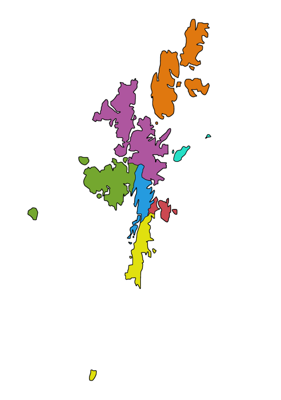
As part of the process around developing Shetland’s Partnership Plan, we also gathered information about areas within Shetland. Using a range of data sources we then created a series of Locality Profiles.

These Locality Profiles are designed to be a snapshot of the Locality with some comparisons to the Shetland data; and they include a blurb about the localities, contact details, data sources, and links to the website for more information. These profiles cover:

Shetland Central, Blue: #259bdfShetland Central
Lerwick and Bressay, Red #CB4851Lerwick & Bressay
Shetland North, Purple #AE569FShetland North
Shetland South, Yellow: #e0e00fShetland South
Shetland West, Green: #74a72fShetland West
Whalsay and Skerries, Teal: #25dfc6Whalsay & Skerries
Yell, Unst and Fetlar, Orange: #e0780fYell, Unst & Fetlar


View and download the profiles here

A map of Shetland, with each locality marked out by a specific colour. Lerwick and Bressay is red, Shetland Central blue, Shetland South yellow, Shetland West green, Shetland North purple, Yell Unst and Fetlar orange, Whalsay and Skerries teal.

image of all profiles

Protected Characteristics Profiles

In preparing the Equality Outcomes and Mainstreaming Report 2025-29, Shetland Islands Council collected data on the diverse characteristics within Shetland. Using a range of data sources, they created a series of nine Protected Characteristic Profiles.

These Profiles provide a snapshot of the community, with comparisons to Shetland-wide and National data. They aim to inform discussions about our local community by increasing awareness of existing data. They serve as a valuable tool to consider the impact on individuals with protected characteristics when planning any projects, plans, or proposals. These profiles cover: 

  • Age
  • Disability
  • Gender Reassignment
  • Marriage and Civil Partnership
  • Pregnancy and Maternity
  • Race
  • Religion or Belief
  • Sex
  • Sexual Orientation.

View and download the profiles here


Resilience Leaflets for Islands with Small Populations

Leaflets have been produced for each of Shetland's Islands with Small Populations, to provide residents access to dedicated resilience information for their location.  These leaflets contain advice, emergency contacts, information on medical provisions, locations of defibrilators, and can assist residents and visitors in emergency situations.

View and download the resilience leaflets

Shetland Islands map blue outline, with the small Islands filled in blue.